


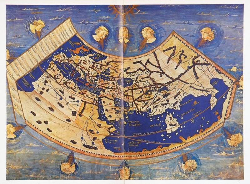
The mapping of Australia holds a special place in the history of cartography, as both the search for the mythical Terra Australis or South Land, and the subsequent exploration of coastal and inland Australia cover the time period over which the printed map has developed. Old maps in the Australian context are traditionally considered to date from 1477 when the first collection of printed maps was published in Bologna. These maps were derived from Claudius Ptolemy’s Geographia, a work of considerable scientific genius that laid the foundations of modern geography and cartography in the first century AD and dominated the geographic thinking of the Christian and Muslim worlds for 1,500 years.
Credit for the physical discovery of the Australian continent, particularly parts of the north and west coast, is generally given to Dutch navigators in the early years of the 17th century as they sailed south from Batavia in their bids to determine the trading potential of the South Land. The philosophic commitment to the concept of Terra Australis, as a geographical necessity to maintain the balance of the Earth’s distribution of land masses, dates back two thousand years to the ancient Greeks.
The medieval editions of Ptolemy such as those published by the German cartographer Sebastian Munster showing the northern rim of a continent called Terra Incognita in the south which might comprise a portion of the coast of Australia stretching from the eastern extremity of the map to Africa in the west thus establishing the concept of a “land-locked” Indian Ocean. This concept delayed the opening up of a sea route to India and the Far East around the horn of Africa for centuries until 1488 when the Portuguese navigator Bartholomew Diaz unwittingly rounded the Cape of Good Hope during a storm and so entered the Indian Ocean from the Atlantic Ocean thus exploding the myth and opening India and the Far East to seaborne trade with Europe.
In 1606 the small yacht Duyfken owned by the Dutch East India Company (VOC) and captained by Willem Janszoon sailed from Batavia on a voyage of exploration looking for “east and south lands” which took it to Australia’s Cape York Peninsula. That expedition became the first historically recorded and authenticated European voyage to Australia. But even the discovery of the continent by Willem Janszoon in 1606 is open to question. There is considerable circumstantial evidence to suggest that fishermen from Makassar in Sulawesi commenced their annual voyages to the north coast of Western Australia, Northern Territory and Queensland or Marege, as these parts of the Australian coast was known to them, as early as the 15th century. These fishermen came to exploit the shallow seas for trepang (a sea-slug sought by Chinese traders as a culinary delicacy with aphrodisiacal properties) and for tortoise-shell, pearl-shell and pearls which they later sold to Muslim traders who took them to the markets of Europe. As well as the “fruits of the sea”, the Makassars also cut and took back with them sandalwood and hardwood logs. In modern-day Makassar, there remain numerous buildings which feature the timbers from Arnhem Land in their construction.
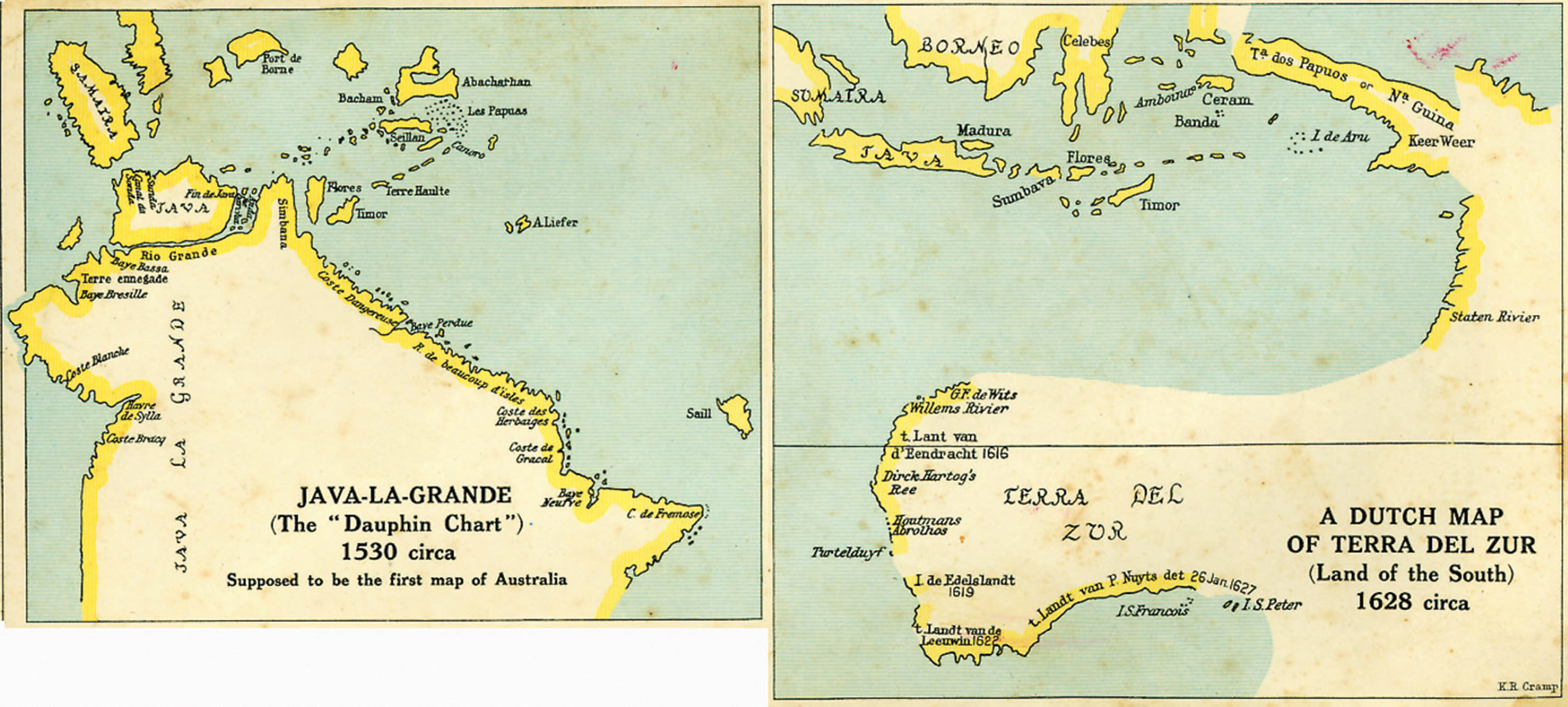
There is further evidence emerging that Portuguese seafarers also visited the north, west and even the east coast of Australia in the early 16th century some 85 years before the Dutch. Between 1536 and 1566, a series of maps of the world were published by various cartographers in the French town of Dieppe, a centre for map production in Europe. The first is known as the Dauphin map as it was given to the Dauphin, the Crown Prince of France as a gift. Though undated, its time of production has been narrowed down to around 1536. The section of the map depicting the Far East includes a section of coastline that had never appeared on maps of the world before, that of a land mass south of Java called Jave La Grande, right where Australia appears on modern maps.
The Viceroy of Goa, Diego Lopes de Sequeira, was ordered by the Portuguese crown to organise an expedition to travel into the uncharted waters beyond the Spice Islands in search of Java Le Grande The official reason for the expedition was to search for gold but the real reason was most probably to intercept Ferdinand Magellan, the Portuguese navigator in the employ of the Spanish Crown, whose arrival in the area was considered imminent in his quest to become the first sea captain to circumnavigate the globe. Clearly, the mission would have been to intercept Magellan before he was able to establish himself there or to establish a Portuguese presence on the south land to counter any similar move the Spanish might make.
Cristovas de Mendonca, a senior officer in the Portuguese Navy who was stationed in Goa, was given the task of captaining the fleet of three caravels to search for Java La Grande. Mendonca set out from Pedir in Sumatra east to Malacca before heading off into the great unknown. What happened to Mendonca after leaving Malacca is shrouded in mystery. All the official records say is that only one of Mendonca’s three vessels returned to Pedir some 18 months after its departure. What happened to the other two ships is not known. De Mendonca’s name does not appear again until 1525, when he is reported to have been in Portugal. During the next few years, he is known to have made a number of trips to Dieppe, France, presumably to sell his charts to the cartographers there. It can only be assumed that one such cartographer bought his charts and from it created the Dauphin map.
The cartographer who drew the Dauphin map clearly believed it represented Marco Polo’s great south land, as it places the newly charted land exactly where Marco Polo described it as being. These correspond not only with Marco Polo’s writings, but also with Mercator’s famous map of the world dated 1569 which calls the large land mass south of Java “beach” and the nearby island “Petan”, the names used in Marco Polo’s writings. It also clearly shows the northwest coastline of Australia from Joseph Bonaparte Gulf to the Gulf of Carpenaria and Groote Eylandt which had not been officially discovered until some 80 years later.
The eleven Dieppe maps differ in the amount of detail they contain, but the one thing they have in common is the size and shape of the coastline of Java le Grande along with a number of named coastal features, evidence that the new additions all came from the one source. The name Java Le Grande is French, which indicates that it was added by the cartographer and not the navigator, who, being Portuguese, would have called it India Meridional. Other names, like Coste Dangereuse and C. de Fremose, are a mixture of French and Portuguese, which clearly identifies the source of the new information as coming from a Portuguese navigator.
If the section of coastline labelled Java Le Grande on the Dieppe maps can be shown to be that of Australia, then the Dauphin map and those similar to it contain tangible evidence that the coast of Australia was visited and mapped by a Portuguese navigator at some time prior to 1536. Though intricate in detail, at a casual glance the squiggly line does not resemble that of any land mass in the vicinity indicated, or any recognisable stretch of Australian coastline. Modern cartographers, after studying the projection upon which this map was constructed and allowing for such things as the magnetic variation of the day and the “erration error” which was inherent in the Portuguese system of navigation then in use, have been able to redraw the Dauphin map on the mercator projection, which is the basis of modern mapping. When this is done, the eastern section of coastline on the Dieppe maps suggests that the Portuguese navigator travelled the whole of the eastern seaboard from Cape York to Bass Strait and beyond, naming many of the bays that James Cook named 248 years later.