

Forest fires have been an annual issue in Indonesia for almost two decades, with the islands of Kalimantan and Sumatra hit particularly hard. According to reports cited in the media, last year the archipelago lost 2 million hectares of forests and peatland due to fires. Many were deliberately lit to make way for plantations – much of the affected land is owned by pulpwood, palm oil and mining companies. The smoke is not just a serious health hazard (last year 19 people died due to the toxic smoke, not to mention the thousands that ended up with haze-related respiratory illnesses), but causes the closure of airports and schools. And it is not just Indonesia that is affected. Last year’s raging fires caused diplomatic tension with both neighbouring Singapore and Malaysia.
In October 2015, President Joko Widodo responded to what the media has referred to as the “biggest environmental crime of the 21st century” by issuing an official instruction to end further development on peatland. In addition, during the International Peatland Conference in November 2015, Vice President Jusuf Kalla called for the restoration of Indonesia’s forests and peatland by 2020. Whether the good intention makes a difference remains to be seen. Many have expressed the concern that President Widodo might find it difficult to enforce his vision across ministries and different levels of government.
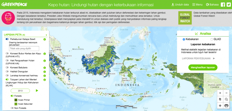
Greenpeace Indonesia launched Peta Kepo Hutan (Curious About Forests) in March 2015, an online ‘near real-time’ map that documents forest fires and deforestation across the country. Teguh Surya, who is a Forest Campaigner at Greenpeace and leads the Peta Kepo Hutan app project, says that the map has been built to provide the public with information and make the culpable parties accountable for their actions.
“We hope to improve forest governance and to achieve a zero deforestation commitment that has been made by the Indonesian government and the business sector,” Surya says. “Even after 70 years of independence, up to now we had [sic] no proper map that could be used as a reference to manage forests and land.”
Surya says that all of the data on the platform comes from official sources, mostly the government, and that Greenpeace has done its best to gather all available information. Digitalized maps and PDF files have been integrated with data from an online portal run by the Global Forest Watch, as well as their data on fire hotspots, deforestation and animal habitats. Global Forest Watch utilizes Global Land Analysis and Discovery, a satellite-based tool that can identify even small-scale deforestation. “On November 30 last year, Greenpeace lodged a request with the Public Information Commission (Komisi Informasi Pusat) to ensure government transparency and access to up-to-date concession maps in a shapefile [digital, scale-able, maps] format.”
The map allows the public to see which company controls or owns the affected land, and whether the fire is on peatland or in primary or secondary forest. It also shows if the fire is on a pulpwood, logging or coal-mining concession, and highlights orangutan or tiger habitats. It is the hope that global companies, which source palm oil and pulp from Indonesia, will take note of whether their suppliers might be contributing to deforestation.
Peta Kepo Hutan ties in with the government’s One Map initiative. Launched by the previous administration, the campaign aims to result in a comprehensive map of land use concessions in Indonesia. Currently, different ministries hold different concession maps due to decentralization following the fall of Suharto in 1998 when the governance of natural resources was ‘devolved’ to district and provincial levels.
Surya says that the fact that the map shows which companies control the affected land means that they could potentially be made responsible and prosecuted for the fires on their land.
Legal experts have been reported as saying that the mapping tool is accurate enough that it could be used as legal evidence in court.
“The public can make direct reports to local or national authorities. In this way, Peta Kepo Hutan can help the government and companies to prevent forest fire disasters,” Surya says. “People need to be educated about forest fires and how to respond to them. The government also needs to develop an online platform that would enable the public to engaged in forest fire prevention. Basically, the main information the public should have is who owns and controls what land.”
And while Surya says that a backlash against the products manufactured by companies found responsible for such fires is unlikely to take place in Indonesia, it might just take place overseas in places such as Singapore. Last year, the Singapore Environment Council led a boycott against the products manufactured by the Asia Pulp and Paper Group, whose concessions were severely affected by fires.
While Indonesia is still recovering from last year’s fires, many hope that the disaster will not be repeated. Peta Kepo Hutan is an important step in the right direction. “Peta Kepo Hutan was born in the spirit of transparency in the management of Indonesia’s natural resources,” Surya says. “I believe Peta Kepo Hutan will be helpful in terms of forest fire prevention as long as the government is committed to sharing their data.”
To view the map:
http://www.greenpeace.org/seasia/id/Global/seasia/Indonesia/Code/Forest-Map/index.html