


The recent flooding followed by the inevitable Jakarta traffic grid-lock must make us look back wistfully to a time when Jakarta really was a big village and the commute to the office was not something to be dreaded. We need to go back to the 1970s for such luxury, but even then urban Jakarta had spread to Cilandak. We need to go back another century and a half to 1800 to see a more rural Jakarta. At the end of the 18th century, the southern boundary of the old city of Batavia was located around present-day Glodok with residential areas spreading south to Ryswick (present-day) Monas and three kilometres west. What constituted modern-day Jakarta consisted of rice fields, plantations, forests, shrub land and villages, set in a landscape of rolling plains and small hills.
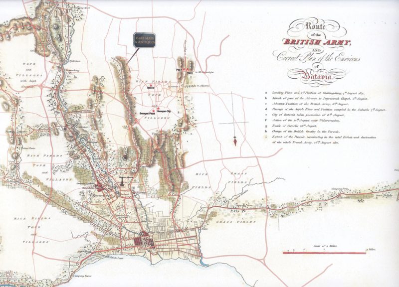
This was the scene that the soldiers of the British army encountered in 1811 when the British Expeditionary force invaded Java as part of a plan to eliminate French influence from the Eastern Seas. The army was ferried ashore at Cillincing by the British navy and the route taken to engage the Dutch defenders was included in a map of the area stretching from Cillincing in the east to Tangerang in the West and Tanjung Barat in the South. This map, engraved by Edward Gullan from sketches and survey data provided by Major William Thorn, one of the senior British commanders, was published in Thorn’s ‘Memoir of the Conquest of Java’ in 1815. The map shows the roads, tracks, rivers and village layout at the time of the invasion in addition to the location of rice fields, grasslands, hills and the built-up areas of the capital city, Batavia.
Looking at the road layout, in particular, prompted Hans Rooseboom, a long-term resident of Jakarta and antique map collector, to speculate whether it would be possible to superimpose the modern road network of Jakarta on this early 19th century map, and thereby see where the modern centres of commerce like the SCBD and residential areas such as Kemang and Pondok Indah are in relation to an 1811 base map. Using modern digital mapping techniques, the 1811 map was first scanned then stretched and adjusted digitally to fit a modern map of Jakarta. Some of the major roads, such as Jalan Sudirman, JORR and the Jakarta Inner City Ring Road were superimposed on the old map together with modern landmarks such as Blok M, Monas and Pondok Indah Mall creating a unique 19th and 21st century map of Jakarta. By providing the geographical coordinates of your office, home, favourite pub or restaurant, it is now possible to have your own 19/21 century map of Jakarta with these specified locations shown on the printed map in the form of your choice. The example shown illustrates the position of the Rare Maps and Antiques Gallery with the gallery’s logo.
The high resolution scanning technology used means that the maps can be printed at a number of sizes of paper and scales from A3 to poster size (A0). Prices are given with and without a referenced location.
Please contact Bartele Gallery on 021 719 0087 for order requests.